Wednesday, 7 September 2011

El Nino - La Nina

El Nino and La Nina are profound short term, widespread inter- annual climate change on a global scale. Since the sun is almost directly above the equator for the whole year, seasonally cycles are much weaker than those we experience in the UK. Consequently, other ocean-atmosphere cycles dominate in the equatorial regions. When atmospheric pressure is low in the Indian Ocean, it is usually high in the Pacific Ocean, contrasting between Africa and Australia, and visa versa.  


Definitions:


  • El Nino  - warm surface waters prevail periodically in the eastern equatorial Pacific. South American fishermen named the phenomena, it is Spanish for ‘The Christ Child’ because it peaks at Christmas.
  • La Nina – colder than average sea surface temperatures in the central and eastern equatorial Pacific. This is described as an exaggerated, more extreme episode of the normal year.
  • Southern Oscillation – atmospheric pressure fluctuations between Pacific and the Australasia area.
  • ENSO – (El Nino Southern Oscillation) is the term used to encapsulate all of the associated natural events.

 
Normal Conditions:


1.      Trade winds flow equatorwards and westwards across the Tropical Pacific.

2.      The winds blow in towards the warm water of the western Pacific.

3.      As the warm water is heats the atmosphere, convectional uplift of air masses occurs.

4.      Upwelling of cool water can take place along the east coast of Peru because of the shallow position of the thermocline and the strength of the westerly trade winds.

5.      The cool water is nutrient rich, boosting the aquatic ecosystem and thus the fishing industry.

6.      The pressure of the trade winds forces sea levels in Australasia to rise by 50 cm above those off the Peruvian coast and the surface sea temperatures are 8 °c higher.

7.   The air over Australasia subsides – known as the Walker Loop.


Sequence of events in an El Nino cycle:


  1. The trade winds in the western Pacific weaken or reverse and flow from eastwards.
  2. This allows warm water currents to flow from the west to the east.
  3. Sea levels level out and surface waters off the south American coast warm, limiting the upwelling of cold deep water.
  4. The eastern Pacific Ocean becomes 6 – 8 °C warmer.
  5. The formation of clouds and tropical storms increases as the surface of the ocean warms. However, rather than being confined to the tropical islands of the western Pacific, they migrate eastwards, affecting usually arid environments like the deserts of Peru.
  6. Conditions are generally calmer throughout the Pacific.

Sequence of events in an La Nina cycle:


  1. Extremely strong trade winds.
  2. Trade winds force warm water westwards, pushing sea level up to 1 m in Indonisia and the Philippines higher than the sea level in the east.
  3. Low-pressure systems form with significantly stronger convectional uplift as the warm air heats the atmosphere. Torrential rainfall is frequent in southeast Asia.
  4. Enhanced up-welling of cold water off the coast of Peru leads to strong high pressure and extreme drought.

The cycle reverses every 1 to 5 years.

Recommended Resources:

A good website for pupils to explore for research based homework:  


Check out what is happening today by analysing the animation from the NOAA. The simulation could be shown to challenge pupils to work out for themselves current stage of the ENSO cycle.

    The Oceans Role in Climate

    ·      Oceans influence atmospheric processes by albedo, moisture circulation and energy transfer.
    • Atmospheric processes influence oceanic processes, for example waves receive their energy from the winds as they blow across the surface of water. The size of waves depends upon the velocity, fetch (how far it travels) and duration of wind.
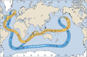
    • Energy is redistributed through oceans by thermohaline circulation. This helps to maintain the global climate.
    Themohaline Circulation

      Thermohaline Circulation


      The thermohaline circulation, otherwise known as the ‘ocean gyre’ or ‘global ocean conveyor belt’, is large-scale oceanic circulation that is controlled by changes in water density (which in turn affects its buoyancy) caused by variations in temperature and salinity. Thermohaline circulation has a symbiotic relationship with global climate. We have already examined how heat is transferred around the Earth by the atmosphere now we must also consider the role of the oceans in the distribution of heat.

      An easy way to remember what thermohaline means is by deconstructing the name:  thermo refers to temperature and haline refers to salt content.

      Two factors determine water density:
      Salinity: the saltier, the denser.
      Temperature: the colder, the denser.

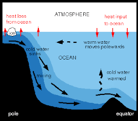
      Ocean circulation is largely controlled by temperature gradients. Water cools and sinks at the poles and travels towards the equator along the seabed. At the equator these currents rise, warm and overturn (upwelling) to flow back towards the polar oceans.


       Seawater is 2-3 % denser than freshwater, therefore, pure freshwater floats.


        How slanity and temperature affect the density of water.
        Processes that increase salinity:
        • Evaporation: removes pure fresh water.
        • Freezing of sea ice: removes pure fresh water.
        • Formation of glaciers: reduces runoff.
        Processes that decrease salinity:
        • Precipitation: adds pure fresh water.
        • Runoff from land (including from melting glaciers): adds pure fresh water.
        • Melting of sea ice: adds pure fresh water.
      Why is the sea salty?

      Salt in the sea or oceans originates from land. Chemical (solution) weathering of rocks and soils on land by aeolian, fluvial and anthropogenic frees up salt compounds that are then transported to the oceans via rivers.


      Other important facts:

      ·        The ocean works for a state of equilibrium – any dissolved salt added to the ocean is removed into oceanic sediment.  
      ·        Temperature variations with depth: at the tropics and temperate regions a thermocline exists, where temperature reduces rapidly with depth. However, in the polar oceans the water is constantly cold from the surface to the seabed.


      The Day After Tomorrow


      The thriller ‘The Day After Tomorrow’ tells the sensationalised story of dramatically abrupt climate change brought about by the shutdown of the North Atlantic oceanic conveyor as a result of rapid melting of the ice caps disrupting the natural balance of fresh and saline water.

      Although time scale is completely unrealistic, the process itself is not completely a fictional. There is strong scientific evidence indicating that rapid ice shelf collapse and increased precipitation in the northern hemisphere caused by the global warming could theoretically tip the balance and instigating the onset of an ice age. The influx of pure freshwater may lead to widespread reduction in North Atlantic surface salinity, thus a decline in thermohaline circulation. In the absence of the Gulf Stream (the surface current within the North Atlantic segment of the oceanic conveyor), Western Europe will loose a significant source of heat – this is believed to be the trigger an ice age or a temporary cold period such as the Younger Dryas. 

      For further investigation into the theory of abrupt climate change I recommend the article 'Abrupt climate change and the thermohaline circulation: Mechanisms and predictability' by Jochem Marotzke. It can be accessed from the Proceedings of the National Academy of Sciences of the USA website:
      http://www.pnas.org/content/97/4/1347.full

      Tuesday, 6 September 2011

      Weather Forecasting

      Data Collection and Analysis


      • Thousands of surface stations collect data at 0000, 0600, 1200 and 1800 GMT based on weather ships and automatic buoys at sea and on land.
      • Upper atmospheric data is captured by radiosondes and aircraft.
      • Lower atmospheric data is collected through vertical wind profilers and radar.
      • Satellites orbiting the Earth including Polar Satellites (NOAA), geostationary satellites (meteosat) and geostationary and operational environmental satellites (GOES) measure and track weather systems. 
      • Data from this range of sources is then transmitted to weather centres and collated by computer models.

      Methods of Forecasting

      1. Synoptic weather forecasting – predict weather system movement using surface and upper air data.
      2. Numerical and statistical forecasting.
      3. Ensemble forecasting – inputting slightly different initial conditions into a range of computer models to predict the likelihood of certain types weather, such as rain or snow.

      Synoptic pressure fields are shown as isobars (lines of equal pressure at a set height).

      Synoptic Pressure Fields

      The closer the isobars the greater the geostrophic wind velocity. (Geostrophic wind flows horizontally and parallel to isobars, they come about when pressure gradient force and the Coriolis force are balanced.) Wind speed is measured in knots, as shown in the table below.


      Terminology

      High Pressure = cool, dry air that is associated with fair weather and light winds (rotate clockwise in the northern hemisphere and anti clockwise in the southern hemisphere)
      Low Pressure = warm, moist air that usually brings stormy weather and strong winds (rotate anti clockwise in the northern hemisphere and clockwise in the southern hemisphere)
      Weather Front = boundary between two different air masses
      Cold Front = where a cold air mass is moving to replace a warm air mass
      Warm Front = where a warm air mass is moving to replace a cold air mass
      Stationary Front = where two air masses merge and don’t move
      Occolude Front = a combination of two fronts when a cold front ‘catches up’ with a warm front
      Trough = an elongated area of low pressure associated with cloud cover and precipitation


      Weather Station Symbols

      Table displaying symbols used on weather charts – BBC GCSE Bitesize


      Classroom Activity - Presenting The Weather

      The class can be divided into small teams of meteorologists faced with different weather scenarios. Building upon prior knowledge of British weather patterns and interpretation of weather maps and synoptic charts, pupils are instructed to interpret infrared satellite imagery from the Met Office to predict the forecast for later that day. Pupils can choose to present their findings as they wish, although a strong recommendation to use ICT could be stipulated to develop their technical skills. Each weather team will be allocated 5 minutes to present their weather forecast.

      The main parameters pupils need to take into account are temperature, humidity, precipitation and atmospheric pressure.


      Lesson Plans/Resources


      BBC Weather Lesson Plan for Key Stage 2 (could be adapted for Year 7:
       
      Fantastic free resources are available to order from the Met Office. The interactive weather presenting kit looks very flashy! 


      Weather For Wiz Kids is a brilliant, colourful website that uses simple language and diagrams to define pressure systems and weather fronts, ideal for Key Stage 3 and 4. 


      Cloud Spotting

      Analysing the shape, size and altitude of clouds gives meteorologists a good indication of the atmospheric conditions, including air stability, moisture content and motion. Clouds are classified on the basis of the height and form. The three main types for types of cloud are Cumulus, Cirrus and Stratus:


      1. Cumulus clouds exhibit flat bases, rising domes with bubble/globular cloud masses. These can grow from unstable air that rises vertically from low altitudes to up to 45,000 feet (in extremely unstable conditions). Cumulus clouds consist water vapour at low altitudes and ice crystals at high altitudes.
      2. Cirrus clouds are white, high and have a wispy appearance. They form at high altitudes and are composed of ice crystals, dust or pollution partials.
      3. Stratus cloud form at low altitudes as expansive sheets or Stratas. Low-level stratus clouds are composed of water vapour and are usually associated with precipitation.
      Rain-producing clouds contain the prefix ‘nimbo’ or suffix ‘nimbus’ within their name.
      Classification of clouds:


      Cumulus clouds

       
      Cirrus and Cirrostratus develop as a result of strong vertical shear
      between two air streams. When the upper stream flows faster than
      the lower stream wave-like pattern are created.  


       Bands of Altocumulus clouds form as a result of turbulence induced
       by dramatic changes in surface roughness i.e. as air masses flow over
       hills and mountains.

      Noctilucent clouds are very rarely seen in the UK. They emerge so
      high in the atmosphere that is illuminated by the sun even at night,
      estimated to form 70-90km (44-45 miles) above sea level.

      Class Exercise:
      What type of atmospheric conditions produce these different types of clouds?


      A quick and fun match up game available at


      Monday, 5 September 2011

      Smog


      Claude Monets The Houses of Parliament, painted in 1904
      depicts the filtering of sunlight, intercepted by the thick smog
      of Edwardian London
      London shrouded in smog, April 2011.

      Smog is a type of ground-level ozone that is produced by complex photochemical reactions between organic compounds, nitrogen oxides and sunlight. These particles of pollutants become suspended in the atmosphere appear as a brown haze above a city. Certain weather conditions and geography affect the location and severity of smog.


      Winter smog can form under an anticyclone, when a temperature inversion is coupled with high concentrations of sulphur dioxide and other gasses produced from the combustion of fossil fuels emitted by vehicles and industry. Calm conditions exacerbate the conditions; pollutants remain in situe as they cannot be flushed away by air currents. Exposure to air pollution is linked to the contraction of respiratory diseases and aggravates asthma.


      Conditions for smog development:

      Temperatures and sunlight determine the length of time it takes for smog to form – high temperatures and high sunlight intensity increase the rate of smog development when upper air is warm enough to inhibit vertical circulation. A temperature inversion can induce smog formation, where normal temperature decrease with height (lapse rate) switches to temperature increase with height. The inversion acts like a lid, preventing convective overturning air currents from breaking through the layer of warm air.


      The topography of a city can determine the severity; cities that are most prone to smog lie in geological basins, enclosed by hills/mountains that trap the pollutants. Mexico City and Los Angeles are prime examples of smog exacerbated by the local topography.  

      The population density of a city affects pollution levels – densely populated mega-cities like London, New York in the USA, Cairo in Egypt, Seoul in South Korea, New Deli in India, to name but a few.


      Case Study – Mexico City
       

      Situated in a basin surrounded by two major mountain chains, Mexico Cities geography contributes to its susceptibility to smog. Cold air sinks down the mountains and over the urban zone, trapping the heavy volumes of industrial and vehicular pollution underneath a layer of warm air - this is known as a temperature inversion. Due to the topography of the land, winds are unable to push the smog over the surrounding mountains. The highest concentrations of carbon monoxide in the air are usually during the weekday morning commuting period, from 7 – 9 am, when low temperatures, low atmospheric stability and high emissions occur simultaneously. Although winds normally circulate over the city by the evening, particles are not dispersed and transported away from the city completely and are easily blown back down the mountains the following day.


      Smog in Mexico City - a temperature inversion caused by the natural topography.  


      Strategies for improvement:


      1. Imposing driving restrictions by banning cars from the road one day a week
      2. Upgrading the bus network to encourage commuters to switch from private to public transport
      3. The government has cooperated with industry to set attainable goals in reducing emissions.

      Recommended Resource:
       

      Out Reach World provides informative worksheets including an excellent one about pollution in Mexico City and other Mega Cities. A series of exercises with prepared questions or tasks such as ‘propose a pollution prevention plan’ could be used in the classroom or set as homework.

      http://www.outreachworld.org/Files/u_texas/mexico_city_pollution.pdf

      Saturday, 3 September 2011

      Urban Climates


      The Urban Heat Island Effect

      Artificially created ‘Heat Islands’ are becoming increasingly common through the rise in urbanization. Approximately half of the world’s population now live in urban areas. For example, in central London the urban heat island enhances summer night time temperatures by 5-6 °C.


      Contributing factors:

      Anthropogenic heat release - Heat derived from industry and domestic central heating radiates from cities. Especially in high latitude cities and to a lesser extent in mid-latitude cities like Montereal in Canada, which reached a record maximum of 12°C warmer than surroundings in 1971.

      The fabric of a city - Heat retaining (non-reflective) and emitting properties of building materials means that they absorb much of the incident radiation, which in turn is released as heat. This is called the albedo effect.

      The lack of vegetation within towns and cities means that less light is intercepted, less evapotranspiration, thus less vapour is released (which naturally cools air surrounding vegetation).

      Canyon Geometry - The close arrangement of high-rise buildings form urban street canyons found in most cities also contribute to the trapping of heat energy. The dynamics leading to this process is due to the reduced sky view factor that inhibits the escape of reflected radiation back into the atmosphere, causing the radiation to be absorbed by neighbouring structures.

      Within the urban canopy layer (from ground level to roof top) turbulence caused by air flow constricted to urban street canyons, even in light wind conditions, is sufficient to thoroughly mix atmosphere around and above a city, thus affecting the dispersion of air pollution. However, the layout of a city and the characteristics of its buildings can have a profound effect upon circulation. Funnelling of wind between buildings causes localised increase in wind velocity of up to 3 times greater than aloft (otherwise known as the Venturi effect) and clusters of buildings can impede airflow, entrapping pollution leading to potentially harmful concentrations accumulating. Overall wind flow is retarded by the surface roughness of a city, although there is a higher prevalence of gusts brought about by the Venturi effect.

      The urban heat island effect is most detectable at night when the urban atmosphere cools slower than surrounding rural areas.


      Encapsulates all of the processes within the urban heat island.


      Innovations to counteract the heat island effect:


       Ø   The drive to create living roofs in a number of global cities, including New York, where a tax rebate is offered for home owners who install green roofs in metropolitan areas.

      Visit Living Roofs for further details: 


      Ø     Use materials that have a higher solar reflectance (albedo).

      Visit Concrete Thinking for a Sustainable World for an analysis of how concrete can reduce the heat island effect through increasing surface albedo: